At the moment I am not receiving data that can be posted on this site. Therefore, I am not updating the information, but I am continuing to provide analysis and commentary on the main site. Please take a look here:
http://daveslandslideblog.blogspot.com/
Dave
Saturday, July 3, 2010
Wednesday, June 9, 2010
Attabad - situation report (Updated 26th June 2010)
Commentary and analysis accompanying this data is provided on Dave's Landslide Blog.
Situation as per 25th June:
Lake depth: 116.7 metres
Change in lake depth in last 24 hours: +0.13 metres (negative number = fall in lake level)
Spillway discharge: 352 cubic metres per second
Estimated seepage: 6 cubic metres per second
Estimated total outflow: 358 cubic metres per second
Estimated total inflow: 419 cubic metres per second
Lake level graphs:
Lake level and rate of filling from time of landslide:

Lake level since 21st May 2010:

Flow through the spillway:

Slowing evolution of the spillway at Attabad
Once again I am grateful for Focus Humanitarian Assistance for sending the latest photos of the spillway at Attabad. The rate of change new seems to be slowing as flow is being controlled by the large boulders at the head of the channel. This pair show the downslope side of the channel - the left hand image was taken on 7th June and the right hand image a day later:

Allowing for the slight change in camera angle, there is little indication of major change between the two images. The large boulder on the left side of the upper part of the channel bank has slipped into the water on the right hand image, presumably indicating that channel widening is continuing. Of course there may well be some continued erosion of the bed that would is not visible here.
In the upper channel there is comparably little evidence of change also. The inset image is from 7th June, the main image a day later:

It may be that a more detailed inspection on the ground would reveal a more dynamic system.
It is my intention to stop duplicating posts on the two sites from today, with the Hunza Monitoring Blog being used once again to present data on the state of the dam and the lake, and Dave's Landslide Blog to provide a commentary. On DLB I will also start covering other landslide events again.
Monday, June 7, 2010
Latest image of the spillway at Attabad
The wonderful people at Focus have provided an image of the state of the spillway at Attabad that is very instructive. This was taken today:

The current state of play is I think as follows. Flow appears to be constrained by two blockages but, as a commenter has noted, one is a rock spur out of the channel. The blockage appears to have formed a small waterfall / rapid. Downstream of the blockage the channel has widened dramatically - and indeed a section of the track has now been lost.
To me this suggests that the crisis may be far from being over. In particular, the loss of this barrier could cause a rapid increase in flow rate that could be highly erosive. It is however important to stress that interpreting the state of play from photos is difficult.
Sunday, June 6, 2010
Attabad - an increasingly difficult hazard to manage
Apologies to all who emailed and left messages over the weekend requesting updates.
FWO data collected at 8 am on Saturday suggests that the rate of flow was 124.6 cumecs, whilst the Pamir Times reported yesterday that it was 131.7 cumecs. If so, the discharge time graph looks like this:

Thus, the discharge is apparently stabilising. Various media reports from the site itself suggest that downward erosion of the channel has now reduced, but that some lateral erosion is still occurring. I have not seen any images to confirm this though. The lake has stopped rising for now.
It is hard from here to assess the current position with regards to the dam, or to forecast what will happen next. However, from the start I have held the view that managing this hazard would be somewhat challenging if stable flow became established. The chronic hazard has not gone away, although the acute hazard may have reduced. As there is still a vast quantity of water stored in the landscape, the dam remains vulnerable to a series of processes, including:
Meanwhile, of course those on the upstream side remain isolated, with a huge lake impeding access. The Karakoram Highway remains closed indefinitely, although the boat service has been resumed. During summer floods, when inflow may briefly exceed outflow, the lake level could rise again by a small amount, unless progressive erosion of the spillway serves to lower the lake level. Thus, overall, many challenges remain at Attabad.; it will be interesting to see how NDMA responds to them.
FWO data collected at 8 am on Saturday suggests that the rate of flow was 124.6 cumecs, whilst the Pamir Times reported yesterday that it was 131.7 cumecs. If so, the discharge time graph looks like this:

Thus, the discharge is apparently stabilising. Various media reports from the site itself suggest that downward erosion of the channel has now reduced, but that some lateral erosion is still occurring. I have not seen any images to confirm this though. The lake has stopped rising for now.
It is hard from here to assess the current position with regards to the dam, or to forecast what will happen next. However, from the start I have held the view that managing this hazard would be somewhat challenging if stable flow became established. The chronic hazard has not gone away, although the acute hazard may have reduced. As there is still a vast quantity of water stored in the landscape, the dam remains vulnerable to a series of processes, including:
- An unexpected increase in erosion rate;
- Erosion during flood events (the discharge of the Hunza will rise substantially in the next few weeks);
- A further landslide on the banks of the lake, which could trigger a wave;
- A seismic event.
Meanwhile, of course those on the upstream side remain isolated, with a huge lake impeding access. The Karakoram Highway remains closed indefinitely, although the boat service has been resumed. During summer floods, when inflow may briefly exceed outflow, the lake level could rise again by a small amount, unless progressive erosion of the spillway serves to lower the lake level. Thus, overall, many challenges remain at Attabad.; it will be interesting to see how NDMA responds to them.
Friday, June 4, 2010
Attabad: spillway flow update of 08:30 this morning
There is a mass of confusing and contradictory information about the state of flow in the Attabad spillway, but the FWO data appears to be consistent at the moment. The latest data, again via Dr Sadiq, is that flow was 3700 cusecs (105 cumecs) at 08:00 local time this morning. This makes the graph look like this:

This suggests that we are still seeing an incremental increase in flow. However, interestingly, the rate of inflow and the rate of outflow now appear to be balanced, such that the lake level should stop rising (for a while anyway). If this happens, and spillway flow continues to increase, we will know that erosion is developing.

This suggests that we are still seeing an incremental increase in flow. However, interestingly, the rate of inflow and the rate of outflow now appear to be balanced, such that the lake level should stop rising (for a while anyway). If this happens, and spillway flow continues to increase, we will know that erosion is developing.
Photos of the development of the situation at Attabad
Focus have kindly provided a new set of images of the situation at Attabad with respect to the spillway. I think that these images were taken yesterday.
Most importantly, here is an overview image of the spillway:

It is helpful to compare this with the image of the spillway from 1st June (right hand image):

It is clear that the situation has developed considerably over the last few days. The flow along the spillway has increased greatly, and the lower part of the channel has widened and deepened. Flow appears to still be controlled by the large boulder in the middle of the channel, although the lowering of the channel downstream will be steadily undercutting this.The development of the spring on the channel edge is also interesting.
A closer view of the spillway clearly shows how widening is occurring:

The flow is undercutting the banks, which are then progressively failing. Note also just how much scour is occurring even though the bed of the channel is boulder-strewn - it is clear that at the moment the boulders are not armouring the channel.
A view from the downstream side of the channel is fairly dramatic:

This gives the impression that there is a huge volume of water flowing. However, a look downstream towards the old landslide deposit at Salmanabad (that is the big pile of debris upper right) shows that this is not really the case:

It is clear that the flow is still rather modest, despite the huge amount of erosion that the water has achieved.
Attabad: a different set of discharge data
Thanks to Aftab Sadiq of the School if Civil and Environmental Engineering at NUST for passing on a revised set of spillway discharge data. This set was collected by the FWO. It is almost identical to that published here previously, with one important exception. The graph of discharge against time is as follows (correct to 17:00 yesterday, local time):

The difference between this and the data that I have published previously is shown in this graph:

The key difference is for the data of 2nd June, when the FWO recorded a rather higher discharge than did the earlier dataset. I noted yesterday that the linear trend in the earlier dataset was somewhat odd - the FWO data does not show this. The difference is minor on the one hand, but important on another. If we take the original dataset, the apparent sudden stepped increased in discharge yesterday appeared to suggest a major change in process - i.e. that erosion had initiated. The FWO data suggests that the process is unchanged - i.e. we are continuing to see an increase in flow associated just with the increasing lake level. Given that as far as I am aware no breach has developed, my inclination is that the FWO data may have captured the processes on 2nd June better, but this is uncertain at the moment.
It will be very interesting to see what today's data might bring. As it appears that discharge and inflow are now coming close to each other we might expect to see the discharge plateauing. However, some channel erosion will continue, so the situation is far from resolved.
Discussions with the team that dealt with Tangjiashan showed that one of their key concerns was that overtopping would be followed by equilibrium conditions, leaving the hazard in place and creating a very difficult management task downstream. At Hunza we have a repeat of this situation. In the end at Tangjiashan they resolved this by blasting the boulders that controlled the flow in order to initiate a breach event. Given that they do not communicate with me at all, I have no idea what the plans of NDMA might be.
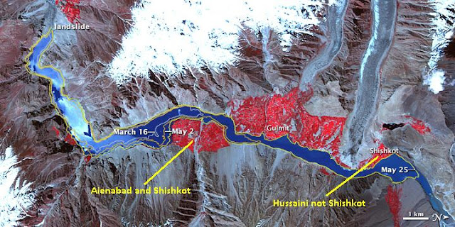
Finally, there is a new NASA ASTER image, collected on 1st June, of the site available:

However, thanks to G.M. Shah of AKU for pointing out that there are some errors in the labeling on this series of images. The key issue is that the location of Shishkot is incorrect:
I will post again when I have further information. And finally, from a personal perspective, thanks to all who wished me luck in my move - it is complete. I am now getting used to living on my own for the first time in 16 years!

The difference between this and the data that I have published previously is shown in this graph:

The key difference is for the data of 2nd June, when the FWO recorded a rather higher discharge than did the earlier dataset. I noted yesterday that the linear trend in the earlier dataset was somewhat odd - the FWO data does not show this. The difference is minor on the one hand, but important on another. If we take the original dataset, the apparent sudden stepped increased in discharge yesterday appeared to suggest a major change in process - i.e. that erosion had initiated. The FWO data suggests that the process is unchanged - i.e. we are continuing to see an increase in flow associated just with the increasing lake level. Given that as far as I am aware no breach has developed, my inclination is that the FWO data may have captured the processes on 2nd June better, but this is uncertain at the moment.
It will be very interesting to see what today's data might bring. As it appears that discharge and inflow are now coming close to each other we might expect to see the discharge plateauing. However, some channel erosion will continue, so the situation is far from resolved.
Discussions with the team that dealt with Tangjiashan showed that one of their key concerns was that overtopping would be followed by equilibrium conditions, leaving the hazard in place and creating a very difficult management task downstream. At Hunza we have a repeat of this situation. In the end at Tangjiashan they resolved this by blasting the boulders that controlled the flow in order to initiate a breach event. Given that they do not communicate with me at all, I have no idea what the plans of NDMA might be.
Finally, there is a new NASA ASTER image, collected on 1st June, of the site available:

However, thanks to G.M. Shah of AKU for pointing out that there are some errors in the labeling on this series of images. The key issue is that the location of Shishkot is incorrect:

I will post again when I have further information. And finally, from a personal perspective, thanks to all who wished me luck in my move - it is complete. I am now getting used to living on my own for the first time in 16 years!
Thursday, June 3, 2010
Attabad appears to have shifted to the next stage
In brief, the discharge at Attabad appears to have dramatically increased in the last few hours, as the graph below shows:

I am trying to find out more information, but it appears to have shifted to a new phase of activity. Inflows and outflow may be approaching a balance. Downstream communities need to be very alert now.
More as soon as I get it.

I am trying to find out more information, but it appears to have shifted to a new phase of activity. Inflows and outflow may be approaching a balance. Downstream communities need to be very alert now.
More as soon as I get it.
Wednesday, June 2, 2010
Attabad - so why hasn't it breached yet?
Several people have emailed to ask why the lake has yet to breach. Well, I would like to emphasise two things - first, that every landslide is different, so predicting the behaviour of any particular slide is effectively impossible. Second, there is a peculiarity about the spillway that appears to be delaying the breach event.
Regular readers (of which there are now several thousand each day I think - thanks to you all) may remember that a few days ago I noted the presence of a large boulder in the channel, right at the crown of the spillway:


Well it is this boulder that is preventing the scour from propagating upstream and that is, in effect, protecting the upper part of the channel against further erosion, as this image shows. The boulder is circled:

The lower part of the channel is continuing to erode with some power, and the channel is widening. The red lines show substantial cracks suggesting further potential widening. The steepest part of the channel is continuing to erode backwards, such that sooner or later the boulder will start to be undercut.
Meanwhile, there appears to be an increasing level of frustration about the very confused spillway discharge statistics emerging from NDMA. This is understandable. If we take the last four daily reports we get:
29th May 18:00: 150 cusecs (cubic feet per second) from the spillway, 350 total discharge
30th May 18:00: 900 cusecs total discharge
31st May 18:00: 900 cusecs total discharge
1st June: 18:00: 1050 cusecs discharge at Ganesh Bridge.
This is a quite bizarre mixture of measurements, but we should all understand that the NDMA team dealing with this are under huge pressure too.
Meanwhile, the more reliable measurements of inflow suggest that the rate is continuing to increase linearly with time, probably because of the choke provided by that boulder. However, I am very surprised by just how linear this increase is proving to be, so please treat this with some caution:

The lake level upstream continues to rise, increasing both the damage and the amount of water in the lake. In the last 24 hours the lake level rose by 75 cm, perhaps suggesting that the rate of inflow is further increasing.
Finally, several people have emailed to ask why I have not covered the multiple landslide accidents around the world in the last few days, including the multiple slides in Central America (and that amazing sinkhole), the landslides in China, the non-fatal slide in New Zealand, etc. I will try to catch up on all of those things as and when this event ends - please accept my apologies. You will understand that I have to maintain my day job whilst doing this, plus yesterday and today I am moving house!
Attabad - flow continues to increase with time
The Pamir Times reports that as of lunchtime today the flow through the spillway had increased to about 850 cubic feet per second - i.e. 24 cubic metres per second, giving a discharge - time graph that looks like this:

For the last 72 hours or so the increase in discharge with time appears to have been linear, which is interesting. This suggests that erosion of the saddle has yet to initiate fully. Fortunately so far the in situ (i.e. not excavated) lacustrine silt and clay has been more resistant to erosion than some had speculated, although the disturbed (excavated and dumped) material has proven to be very erodible. However, the inflow remains more than three times greater than the outflow (seepage plus spillway flow), and retrogressive erosion will in due course steepen the channel, which will increase the erosive potential.
In the meantime the level of the lake is continuing to rise at 50 cm or so per day, with the upshot that further flooding is occurring upstream. The Pamir Times has a tragic (but beautifully shot) photo piece (plus here) on these continued impacts. The level of impact up there is all too clear:

Tuesday, June 1, 2010
Attabad - continued retrogression. Close to the next stage?
The latest images from Attabad suggest that the retrogressive erosion in the channel continues to accelerate, and that this is now by far the most likely failure mechanism. A breach now looks to me to be inevitable. This image, taken this afternoon, shows how the spillway has developed:

Note the people on the road for scale.
Compare it with yesterday's image:

The waterfall has now smoothed out, probably because the water is now eroding the landslide mass rather than the excavated material from the spillway, to create a set of rapids that are clearly eroding back up the channel. The head of the rapids are close to the saddle. The key point is probably the location where the channel become notably steeper - this is where scour accelerates. One this point is reaches and passes the saddle, the rate of flow will start to increase and we might well see the breach developing. Unless the top of the rapids is being impeded by a large boulder or similar, this will probably develop quite quickly.
It remains hard to know how quickly this will develop once the saddle is reached, but downstream communities need to be prepared for a rapid breach.
Attabad - further retrogressive erosion
The latest photos from the site, taken late yesterday, show that the retrogressive erosion of the channel is continuing to develop rapidly. This image was taken at about 5 pm yesterday:

The lower part of the channel has widened and, more importantly, the steep section has moved up channel considerably. Bear in mind that this image is more than 15 hours old now. The best illustration of the way that this is developing is with this sequence of three images, which are taken about a day apart, starting on 29th May on the left and ending with 31st May on the right:

It seems to me that release of the water in the lake is now highly likely in the next few days. The most likely mode of failure looks to be this retrogressive erosion, which could lead to a rapid release event, but the initiation of erosion through downcutting cannot be ruled out. Downstream communities need to be prepared.
I have received no update on the state of flow in the channel - I will post again when some information becomes available.
Monday, May 31, 2010
Attabad - flow and erosion are continuing to accelerate
Flow through the spillway at Attabad has continued to develop during the day. However, as I suggested in my post this morning, some of the higher discharge values being quoted are without foundation. At 6 pm the discharge was about 360 cubic feet per second (10.2 cubic metres per second). Thus, the discharge graph looks like this:

At the moment there appears to be little evidence from these figures that large-scale scour and erosion has been initiated - the increase in flow appears to be the consequence of the increasing lake level, plus perhaps some lateral erosion.
However, erosion at the toe of the slope remains the major concern, with reports suggesting that the gully is continuing to erode back through the channel. This remains the most likely failure mode of the dam, but this may take a few more days to initiate. In addition, the increasing channel discharge may cause the flow velocity to increase to the point at which basal erosion starts. This has not yet happened, but could begin at any stage.
There have been various comments on the blog that the dam is not behaving as expected - i.e. erosion is not initiating - and that as a result measures should be taken to encourage erosion. I want to stress that this is not correct - from the start we knew that it could be that it could take some time for erosion to initiate. So far I see nothing surprising in the behaviour of this system, and nothing to suggest that erosion will not allow a lowering of the lake level in the next few days. At the same time, it is important to emphasise that the probability of a rapid breach has not diminished, and may in fact have slightly increased due to the headward erosion of the lower gully.
There is no need to panic, but at the same time there is also no justification for lowering the alert status. We all need to be patient and alert - this has a long way to go yet. If you are in the area please pay attention to the local alert system.
Attabad - flow on the spillway continues to develop slowly
The discharge across the spillway at Attabad is still increasing. Whilst some reports suggest that it is higher, the Pamir Timeshttp://pamirtimes.net/ suggests that the flow at 2 pm local time was 250 cubic feet per second (7.08 cubic metres per second). If this is correct, the discharge time graph looks like this:

However, the situation is now somewhat confused as the NDMA report from 6 pm on 30th May (i.e. yesterday) was that total outflow was 900 cusecs (25 cubic metres per second). Assuming that 250 cusecs is seepage, this would give a spillway flow of 650 cusecs (18.4 cubic metres per second). This seems to be surprisingly high. Maybe the NDMA information has the wrong time stamp?
Therefore, at the moment I am a little confused as to what is happening. I will try to clarify this in the next few hours.
Sunday, May 30, 2010
Retrogressive erosion at Attabad
Flow continues to increase at Attabad. Inflow is still exceeding outflow and seepage, so the lake level continues to rise, to the detriment of the upstream communities. There has been some confusion about the statistics about outflow - it is now clear that NDMA discussions often use the combined spillway plus seepage figure, but that this is interpreted by the media as being the spillway flow. According to the NDMA press conference tonight, combined seepage plus spillway is about 400 cubic feet per second (about 11 cubic metres per second), still less than 20% of inflow. The remaining 80% will mostly need to be accommodated by the spillway, so this has a long way to go yet.
Downcutting on the saddle of the spillway, where the gradient (and thus the water velocity) is low, appears to be limited at the moment. Looking at the following two images, all of the action is on the downstream face. This picture was taken between 8 am and 9 am local time this morning:

Note the clear erosion (deep downcutting) in the lower part of the channel, which appears to be driving some local instability too. The following picture was taken just before dark (hence the lower quality), between 6 and 7 pm (local time):

Look carefully at the erosion in the lower part of the channel - the two waterfalls are clearly eroding back through the channel. This is a common mode of failure for landslide dams - indeed I highlighted it a couple of days ago. As the discharge through the channel increases we might seethe rate of retrogression of these faces increase. On the other hand, initiation of downcutting in the channel might eliminate them altogether.
Certainly these features need to be watched very closely over the next few days. IF (and it is a big if - by no means a certainty) these features started to erode through the saddle then a fairly rapid failure could develop. However at the moment there is no need to worry unduly - this is just something to watch carefully.
Finally, failures continue to occur on the main scarp above the dam. This one happened early this evening:

It did not result in a wave.
Reported increases in spillway flow at Attabad
If you live in the Hunza and Indus valleys, please do not rely upon this blog to provide warnings and up to date information.
Using only reliable reports in the media (mostly information from the Pamir Times) and those from NDMA, the following graph shows the reported flow through the spillway at Attabad. There is a huge caveat here regarding the reliability of the reports. However, the most recent figure is the NDMA reported value. Times are local to Pakistan (UT +5 hours)

It is clear that flow is now increasing quite rapidly. However, do not be panicked by this - it is as we would expect and does not indicate anything in particular at this stage. Meanwhile of course the water level in the lake is still rising at about 2.5 cm per hour, which will be increasing the impact on the upstream communities. We must not forget them is this crisis.
If you live in the Hunza and Indus valleys, please do not rely upon this blog to provide warnings and up to date information.
Attabad - flow on the spillway continues to develop slowly
Flow through the spillway continues to increase slowly. So far there are no signs of the development of a breach, but the amount of water passing through the spillway remains much less than the inflow. This image, taken yesterday morning, shows water passing through the channel:

The difference between the flow in the channel and the amount of water coming through the dam as seepage (the large channel bottom right) at this time is very clear. The channel flow at this time was in the order of 20 cubic feet per second; the seepage is over 100 cubic feet per second. Since then channel flow has increased (I'll blog on this shortly).
It is important to stress that the threat has not reduced. There was always a good chance that flow would develop slowly and that erosion would take time to initiate. Flow needs to reach >2,500 cubic feet per second to equilibriate the lake level even at the current rate of inflow. The river discharge will more than double over the next month, putting further stress on the spillway. The best image illustrating the latent threat at this site is this one, also taken yesterday:

At the moment this is very reminiscent of the early stages of flow at Tangjiashan:

Attabad overtopping - first image
The Daily Times has published the first picture of the spillway in operation:
 Meanwhile, the Pamir Times reports that: "The volume of water passing through the spillway has reportedly increased to around 50 Cusecs". 50 Cusecs is 1.4 cubic metres per second. This is still a fraction of the total inflow, so we have a long way to go.

Saturday, May 29, 2010
Attabad: initial flow established
Please note that it is hard for me to keep up to date with this evolving situation. If you are potentially-affected by this hazard please use the formal channels of communication set up by the government. Do not rely on this blog to provide warnings.
Flow through the spillway is now properly established and is increasing with time. The latest NDMA report suggests that flow is 300 cubic feet per second (8.5 cumecs), which sounds surprisingly high - indeed I am sceptical of this figure. UPDATE: The Pamir Times is reporting 25 cubic feet per second (0.71 cumecs). this figure sounds more sensible. Reports suggest that so far the flow is stable.
So where does this leave us? Well, as I suggested this morning, erosion is likely to take a while to develop, so we are far from out of the woods as yet. Some lateral erosion at this stage might be helpful in widening the channel, increasing its capacity. However, as the flow increases the chances of the channel becoming blocked will slowly reduce, but again it is too early to eliminate this possibility. As flow increases the potential for erosion also rises, so for me the critical period is from now until the point at which outflow = inflow. This point is some days away.
It is clear that the authorities are taking this very seriously now, with helicopter surveillance in addition to the land-based monitoring. This is good to hear.
Attabad: overtopping has begun
"The next 12 hours could be crucial as the water flow would reach its maximum intensity," commented an official of the National Disaster Management Authority (NDMA), the organization mainly responsible for the overall rescue and damage control operation.
Maybe this is a misquote? The next twelve hours are crucial of course, but there is a good chance that a breach won't develop in this time. The water level will continue to rise until outflow (seepage + spillway flow) = inflow. As some of the water is being released, this may well take much more than 12 hours to develop. In addition, a breach will only start when erosion of the base occurs at the highest point of the saddle. This may well take time to occur.
So, I would like to make two points:
1. The development of a breach in the next 12 hours is very possible; the failure of a breach to develop does not mean that one won't occur. At Tangjiashan the breach took several days to start, but was then rapid;
2. It is also possible that an initial small flood will happen, but that this will then cease. For example, this could be the case if the sides of the channel collapse, blocking the flow. We must be clear that if there is a small flood that then declines then the situation is certainly not over. People must not go back into the danger zone until we know that the threat has passed.
Of course what we are hoping for now is slow erosion and the release of the water over the next few days. Such a scenario is certainly not beyond the bounds of possibility.
I will post again as more information becomes available, but don't be surprised if this takes a few days to develop.
Friday, May 28, 2010
Attabad: freeboard report 28th May
The media in Pakistan are reporting that the freeboard is now 2 feet (61 cm). Assuming that this was taken at the normal measuring time (i.e. 3 pm local time) the freeboard graph looks like this:

Jean Schneider, who is on site and flew over the spillway today, reports that overtopping should begin overnight.

Jean Schneider, who is on site and flew over the spillway today, reports that overtopping should begin overnight.
Attabad: Overtopping is now likely to be imminent
It is unfortunate timing that the likely day of overtopping has fallen on a Friday, the holy day in Pakistan, meaning that flow of information is impeded. As a result I have not yet had an update for today on the lake level. Jean Schneider of BOKU visited the site yesterday by helicopter and measured the freeboard at 2.25 feet, which is about 70 cm. I am not sure what time this measurement was made. Based upon the rate of rise of water level, that should put the time of overtopping at some time today. However, this will depend upon the continued rise of the water at a similar rate, no further heave of the floor of the spillway and, perhaps most importantly, no further collapse of the walls of the spillway.
Meanwhile, the continued mixed messages from the Pakistan administration has been illustrated by an article in The News today:
"Zameer Abbas, Assistant Commissioner and in charge of relief camps in Hunza Nagar, told this correspondent that the Karakoram Highway had been closed for every kind of vehicular traffic as the lake water was expected to reach spillway today (Friday) after which the overflow would begin, paving the way for controlled release of water. Dismissing the chances of water outburst, he said the landslide blocked some one-and-a-half portion of the Hunza River and it was apparently out of question that water would force out of this huge amount of mud and debris."
I will post again when more information becomes available. I will probably put this on my other blog first: http://daveslandslideblog.blogspot.com/. Please can you email me at: d.n.petley@durham.ac.uk, and/or add a comment to this post, if you have news on the situation.
Thursday, May 27, 2010
Attabad: the freeboard is now reportedly about 1.3 metres
The latest NDMA figures suggest that the freeboard is down to about 4.3 feet (1.31 metres) as of 3 pm today. That is a reduction of about 70 cm on the day, meaning that we are probably less than two days from the point of overtopping:

I am reasonably confident of these values as the Focus geologists took this picture yesterday of the spillway:

The circled boulder is the crest of the spillway, so water flow will start when this point is reached. Of course the one potential problem is a slope failure on the spillway walls, which could block the channel. This is a real possibility, but we won't know until tomorrow.
Close up the channel at this point looks like this:

Unfortunately the large boulder will resist lateral cutting, initially at least, which is likely to increase the rate of down-cutting. This is unfortunate. Once the water reaches the top it will initially flow down this channel, crossing the summit of the dam:

And then will flow down here:

The disturbance here is from collapse of the banks induced by the seepage. Finally, it will flow down the main river channel:
 The terrace in the centre left of the image is at 60 metres above the river level. Previous (comparatively recent) floods have not reached this level, which is half the height of the dam. This is the level that we believe is comparatively safe from the flood.

I am reasonably confident of these values as the Focus geologists took this picture yesterday of the spillway:

The circled boulder is the crest of the spillway, so water flow will start when this point is reached. Of course the one potential problem is a slope failure on the spillway walls, which could block the channel. This is a real possibility, but we won't know until tomorrow.
Close up the channel at this point looks like this:

Unfortunately the large boulder will resist lateral cutting, initially at least, which is likely to increase the rate of down-cutting. This is unfortunate. Once the water reaches the top it will initially flow down this channel, crossing the summit of the dam:

And then will flow down here:

The disturbance here is from collapse of the banks induced by the seepage. Finally, it will flow down the main river channel:

Wednesday, May 26, 2010
Attabad: update report for 26th May
The combined monitoring effort appears now to be providing consistent measurements of the remaining freeboard, and these are now being used in the media, which is helpful. As of late last night the reported freeboard was 8.8 feet, which is 2.56 metres. This provides a freeboard - time graph that looks like this:

This suggests that we are still on course for overtopping on about 27th or 28th May, although clearly this remains a moving target for all the reasons previously outlined.
Meanwhile, the media in Pakistan have now picked up on the inconsistencies in the measurements reported by NDMA, and in particular their incorrect measurements of freeboard. This article is strongly critical of the error by the government agencies:
"However, during a tour of the dam site on Monday the NDMA chairman, Nadeem Ahmed, discovered significant differences in measurements recorded by the Frontier Works Organisation (FWO) and the Gilgit-Baltistan region’s public works department. “He was furious when he noticed the discrepancies and realised the NDMA had been reporting inaccurate data,” a participating official said. Mr Ahmed immediately ordered a dam-site demonstration of the methods used by the two government agencies, before declaring that the public works department’s “freeboard auto-level gauge” system, based on instrumentation manufactured by Nikon of Japan, should in future be the sole official data source
Again the question has to be asked as to why NDMA did not use the expert advice that was freely offered? This decision continues to mystify me.
The state of the spillway is also a concern now within Pakistan. From the same article:
The engineers said the 25-metre-deep spillway was too narrow to accommodate outflows of more than 2,400 cusecs from the lake, which held an estimated 1.2 million cusecs on May 17. A cusec is a unit of water flow equal to one cubit foot per second. "There is a serious possibility that the entry of water into the spillway could trigger a collapse of debris that would block it altogether,” an engineer said.
Several people have asked why the slopes on the sides of the spillway are failing given that the weather is dry. The answer I think lies in the material - which dries on the surface but remains wet and very weak just below - and the loading from the excavated materials on the slopes above the spillway:

Finally, the Pamir Times have published a photo of the dam from the upstream side. The watermark is a shame (but understandable). What is notable here is that the upstream face of the dam has undergone a slope failure (the scar is quite obvious on the left side above the lake). This does not threaten the integrity of the dam in any way, but does indicate that the materials from which is it formed are comparatively weak.
I'll try to provide another update later, but have to travel to London to attend the launch of the UCL Institute for Risk and Disaster Reduction this evening.
Tuesday, May 25, 2010
Attabad - a bizarre race between two processes
Yesterdays "coalition" resurvey of the spillway and water level now appears to provide a definitive freeboard value. As of 8 am this morning the freeboard was 3.027 metres, representing an increase of water level of 1.09 metres in the last 24 hours. This elevated rate of water level rise probably reflects the warmer weather in the area in the last few days, which will be driving snowmelt.
I have recalculated the freeboard values assuming that the official numbers released today are correct, meaning the the early figures under-estimated the true freeboard figure. The resulting graph is as follows:

At the current rate of increase the freeboard will be lost in two to three days, but as before we are reliant upon these figures being correct. This episode of incorrect freeboard measurement does not reflect well on NDMA, given the importance of these numbers. Of course, the fact that the saddle is located at a higher elevation means that the lake volume will be larger - i.e. it increases the size of the potential flood.
Of great concern to me though is the continued problem of closure of the spillway. It is clear that the banks of the spillway are failing in multiple locations. These failures are progressively closing the spillway, as this Focus image, taken of the spillway banks yesterday morning, shows:

The concern would be that the spillway closes completely before the water level reaches this level, which would effectively increase the freeboard once again, albeit probably briefly. In effect we are in a high stakes race between the rate of water level rise and the rate of closure of the spillway. The strength of the clay material forming the spillway banks is clearly low, as we believed from the start. Either way, the spillway is clearly completely incapable of handling the flow, so erosion is inevitable. The one bright spot is that the failed banks may erode preferentially, allowing the channel to widen more rapidly than it down-cuts, as happened at Tangjiashan.
Finally, lets not forget the hardship that this crisis is imposing on the local people. The Pamir Times today puiblished this image of a camp for Internally Displaced People (IDPs):

I need say no more.
Subscribe to:
Posts (Atom)